Measurements

Real-Time Wave Measurements
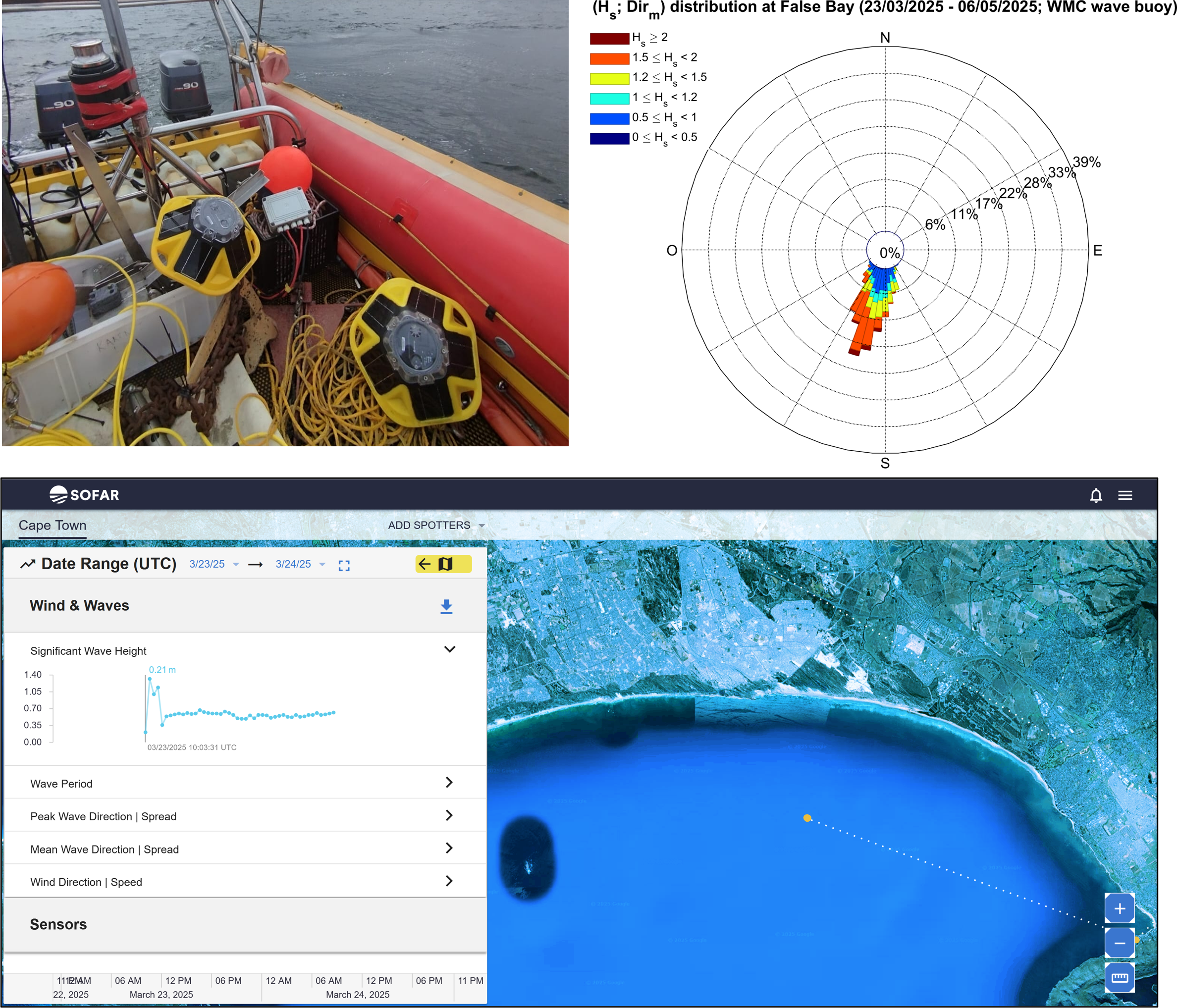
WMC operates Spotter wave buoys (Sofar) that measure wave parameters in real time (mean parameters and directional spectra). Data are transmitted via satellite (Iridium) or cellular network, enabling near real-time monitoring through an online platform.
The images on the left illustrate a one-month deployment of Spotter buoys in False Bay (South Africa), the Sofar online platform used for real-time monitoring, and an example of Hs-Dir distribution derived from post-processed measurements.
High-frequency measurement of the vertical velocity profile
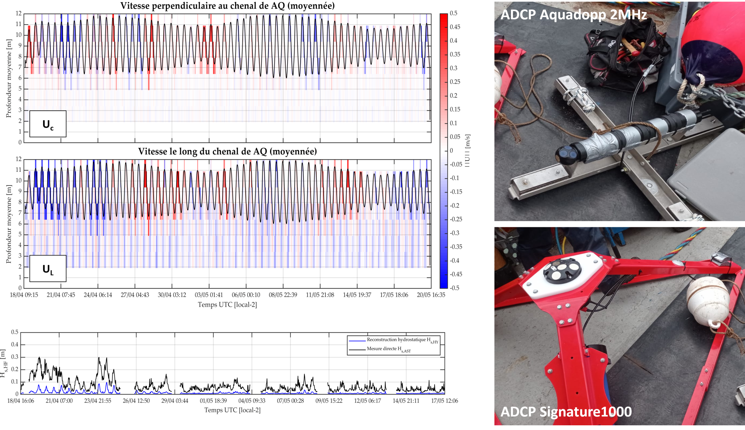
WMC has several ADCPs (Acoustic Doppler Current Profilers; Nortek Aquadopp and Nortek Signature) that measure high-frequency current velocity components (generally 4 or 8 Hz depending on the deployment) at several depths along the water column. They are generally used by WMC for the precise measurement of certain key processes such as wave orbital velocities, undertow, or wind-related vertical shear currents, for example.
The images on the right show an example of ADCP deployment in the Dunkirk port channel for a project to design a breakwater pontoon. The measurements obtained made it possible to analyze the vertical structure of the current components, which are strongly influenced by the tide and surface wind. In addition, the Nortek Signature ADCP features AST (Acoustic Surface Tracking) technology, which provides a direct measurement of the free surface, unlike conventional pressure sensors, which provide an indirect measurement of the free surface (pressure measurement). This direct measurement is a key advantage as it corresponds to the actual measurement of the surface and therefore does not require the application of reconstruction methods with restrictive assumptions about the wave regime.
Pressure Measurements
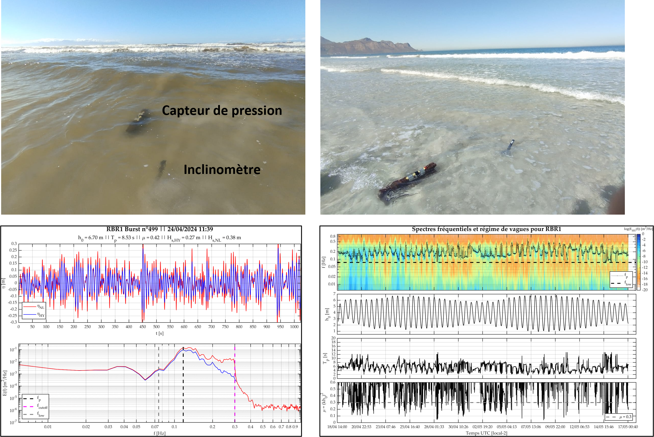
WMC operates several pressure sensors (NKE WiSens, RBRsolo3D) to measure the pressure exerted by waves within the water column. After processing—using, in particular, non-hydrostatic and non-linear reconstruction formulas—the pressure measured at the seabed is converted into free surface elevation, providing estimates of wave parameters (mean parameters, frequency spectra, etc.) and total water level (tide).
The images on the right show an example of pressure sensor deployment in the surf zone at False Bay (South Africa), as well as post-processing results illustrating the reconstructed free surface elevation from pressure measurements using different methods, the associated frequency spectra, and a time series of mean wave and water level parameters from a deployment in Dunkirk (France).
Near-Bed Velocity Measurements
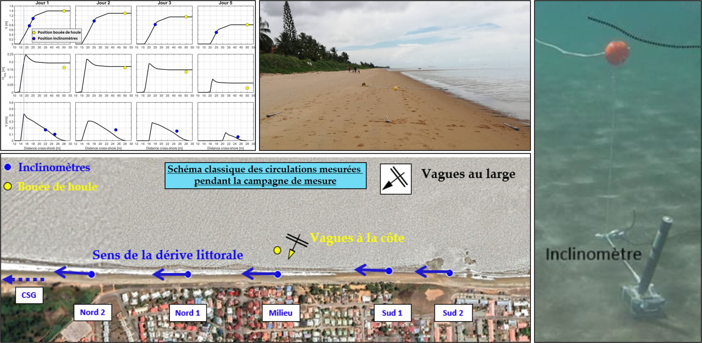
WMC operates several inclinometers (Lowell Instruments) to measure the current velocity components close to the seabed. They are lightweight, easy to use and deploy, and are generally used by WMC to measure mean currents such as longshore drift, thereby enabling the estimation of average circulation patterns at a study site.
The images on the left show an example of inclinometer deployment on the beach at Kourou (French Guiana), coupled with a Spotter wave buoy to measure nearshore currents and waves (deployment carried out at low tide, awaiting the tide to rise for the instruments to become fully submerged). The measurements obtained were used to map the typical mean circulation pattern of the site (in this case, oblique waves generating longshore drift). Another photo also shows an immersed inclinometer measuring near-bed currents in Martinique (French West Indies).
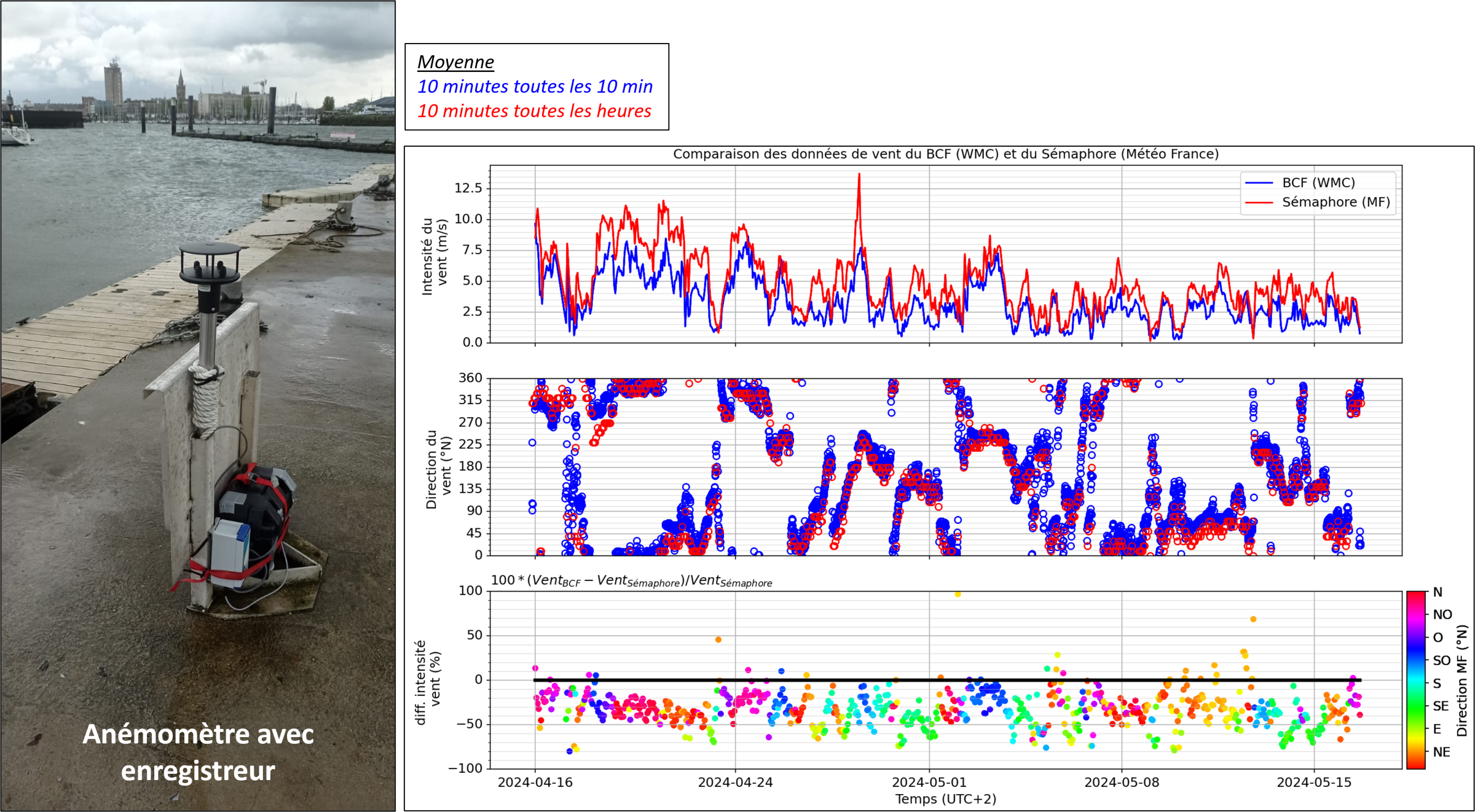
High-frequency wind measurement
WMC has an ultrasonic anemometer (Gilli Inst. Windsonic RS232 Aliance Tech.) that measures wind speed and direction at high frequency. This measurement provides a better understanding of the spatial and temporal variability of the wind by comparing it with measurements at other points (e.g., Météo-France stations) or even with local or global atmospheric models. In addition to providing input for the wave and current models developed by WMC, wind measurements are an important indicator for qualifying and quantifying wind transport (wind-driven sand transport).
The images on the right show an example of the anemometer deployed on the current breakwater pontoon in the project area in the port of Dunkirk. A comparison between the WMC measurement (on the BCF) and the Météo-France measurement (semaphore) is made, revealing the significant influence of the surrounding terrain on the wind.
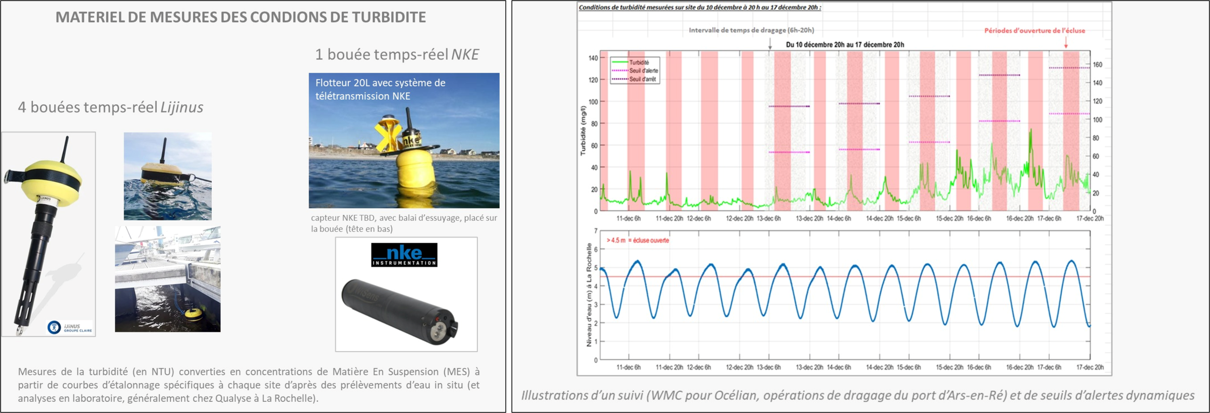
Turbidity measurement
WMC has the means to measure and monitor turbidity conditions in real time, for site characterization or construction site monitoring with alert threshold detection. Several members of the team are recognized specialists in the study of fine suspended sediment dynamics and therefore turbidity conditions in coastal, estuarine, and port areas.